Rosemarket Local History Society has been granted permission by the Medieval Settlement Research Group to reproduce the following extract from an article prepared by Robert Weeks. Details of how to access the full article are provided at the end.
Robert Weeks completed his PhD at the University of Wales, Newport. His thesis is an historico-geographical study of the location, frequency and distribution of markets and fairs in south Wales between the twelfth and fourteenth centuries and the route-ways that linked them. He has worked on two volumes of the Gwent County History series, contributing a chapter on 'markets, trade and industry' to volume two and 'transport and communications' to volume three. Robert has provided heritage consultancy to several local authorities and worked on archaeological excavations across Wales. He has also taught on postgraduate and undergraduate Geography and History programmes at the University of Wales.
Rosemarket
The modern village of Rosemarket is located just under six miles from Pembroke and five and a half miles from Haverfordwest, although the physical divide of the Milford Haven estuary separates Rosemarket from Pembroke. The location of the village in relation to two prominent medieval boroughs, on one of the principal old routeways between the two argues strongly for a medieval origin for the modern village. Early historical evidence for Rosemarket, like many other Pembrokeshire villages, tends to be sparse, there is no borough charter or tradition of borough privileges being upheld in later periods. The clearest indication that a market existed here is undoubtedly in the place name. However, little else was previously known as to when this market existed, its level of success or its eventual demise.
The place name appears to be a derivation of the location name the district of 'Rhos', meaning 'moor' added to the Norman-French word for market, marche. ln 1538 the village of Rosemarket attracted the attention of the antiquarian John Leland who described it thus: 'Rhos market. The market is lost, and (it) is now a poore village. It is as in the middle way bitwixt Arford West and Penbrok' (Toulmin Smith 1972,63).
The village of Rosemarket was granted to the Knights Hospitaller in the mid-twelfth century by William fitz Haion, Robert fitz Godebert and Richard fitz Tancard. Richard was the son of Tancard Flandrensis, a Flemish settlement founder or locator who is believed to have worked extensively in Pembrokeshire and who may have been responsible for establishing Rosemarket. The date of the grant in not known but it is presumed to be from the period 1140-60 (Rees 1947, 26). The 'market of Rhos' is mentioned in an account of Hospitaller possessions from 1308 which transcribes details of properties held by the order in the mid-twelfth century (Charles 1947/48,180).
Rosmarche is mentioned in a petition from the period 1296 - 1301 issued by Joan de Valence, adopting the title 'Lady of Haverford' to the king. Joan held custody of the neighbouring lordship of Pembroke and in this petition claimed jurisdiction over Haverford lordship, which included Rosemarket. This claim had arisen due to the fact that the lordship of Haverford had been administered by Pembroke during the period of transition following the death of Humphrey de Bohun in 1265. This claim was unsuccessful, as in 1273 the lordship officially became administered by the Crown. In 1290 de Valence claims on the lordship were revived, perhaps as an opportunist measure following the death of Queen Eleanor that year, but yet again proved unsuccessful (Rees 1975, 252, no. 151).
The de Valence family eventually gained the lordship of Haverford in 1308. Whilst the village itself is named in the petition, a market is not alluded to and may well have ceased to exist by this time. It had certainly done so by 1338 when Hospitaller records reveal that profits from Rosemarket were derived from a watermill, a fulling mill and the glebe, with there being no mention of income derived from a market (Larking 1857, 34-35). Thus, it must be assumed that the market had been discontinued by this time.
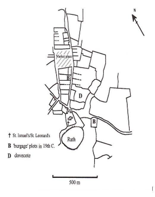
Turning to the village, the basic outline on the tithe map can be assumed to represent the medieval plan of the village. The plan consists of two main streets flanking a centrally located market square. Plots are evident running the full length of the village on its eastern side, and also on two contained pieces of land to the north and south of the market square. Two plots in the village are described by the term 'burgage' on the tithe schedule, though only one of these occurs in the pattern that has just been described. The other is situated as a solitary plot to the east of Rosemarket Rath, a prehistoric enclosure located in a field known locally as meadow ring - on the third main road in the village which runs on a different axis to the two main streets, in an easterly direction. Medieval features within the village include the manor house, a water mill, a fulling mill, and a holy well. The market place survives as a distinct topographical feature despite there being no record of a subsequent market ever being held there.
There is no reference to a market being held in later periods. Surpluses produced within the community were traded elsewhere, notably in Haverfordwest. Arable farming appears to have been an established tradition in the parish of Rosemarket. A considerable stir was created in the 1580s when efforts were made to convert large areas to pastoralism by creating new enclosures (PRO: E112/62/2). It was feared that such actions would lead to depopulation, although the extent to which the conversion from arable to pastoral took place is not recorded. However, the fears of depopulation appear, for the most part, to have been largely unfounded and the scale of the new enclosures made hereabouts may not have been as extensive as was once feared. By far the greatest reorganisation of the landscape in Rosemarket parish has taken place in the later nineteenth and twentieth centuries with the demand by modem farming technology for fewer, larger fields.
Given the evidence outlined above, the possibility should be entertained that Rosemarket is a village that was first laid out as a planned settlement early in the twelfth century, possibly by the Flemish " locator " Tancard whose family retained an interest in the village until its grant to the Knights Hospitallers. It has been speculated by Keith Lilley that Tancard may have been responsible for founding Haverfordwest, Iater taking on the role of castellan (Lilley 1995, 35). The Hospitallers, by 1150, had gained substantial interests elsewhere in Pembrokeshire, notably in Haverfordwest where they acquired an unspecified amount of land along with an additional six burgages in c.1131 (Rees 1947, 26, 120-21). It could well have been this grant to the order that sounded the death knell for the market that was being held at Rosemarket. Tancard disappears from the historical record in Pembrokeshire in 1130 when his son succeeded him as castellan of Haverfordwest. Perhaps it is purely coincidental but it happens to be at the same time that Wizo, the founder of Wiston, also disappears from Pembrokeshire. Different commentators considering each separately have suggested that both men died at around this time, however, men by the name of 'Wizo' and 'Tancard' were founding villages in Scotland in the 1150s (Toorians 1996). These personal names were very rare during the period, consequently there is a very strong possibility that neither had died, but had instead moved on to exploit opportunities elsewhere (Kissock 1997, l3l).
Many of the smaller markets of south Wales had ceased in the early fourteenth century, it is not known if the market at Rosemarket was one of them. Given Hospitaller interests in nearby Haverfordwest it may have been extinguished much earlier. The first charter to Haverfordwest was granted by William Marshall, Earl of Pembroke c. 1200. The extent of any settlement existing before this time is not known, what is known is that Haverfordwest became a chartered borough at least fifty years after Rosemarket had been established. Haverfordwest became the " caput " of its lordship and was well placed at the lowest bridging point of the Western Cleddau to exploit commercial opportunities both by land and sea. It was this strategic advantage in terms of commercial opportunities and also, significantly, in terms of defence, which saw the town expand rapidly. As noted, the exact date of the ending of the weekly market in Rosemarket is not known, however the growth of Haverfordwest, and in particular Hospitaller interests there, may have proved significant in its demise. Haverfordwest may have developed to the extent where it 'achieved' borough status, where Rosemarket failed to do so. Things may have been very different had Rosemarket occupied a location better suited to water transport. As it was, Haverfordwest was not only well served by land routes but more importantly by its position at the furthest navigable point inland on the Western Cleddau, covering some 21 miles, of the Milford Haven estuary (Calendar of Close Rolls 1296-1302, 500).
The medieval history of Pembroke can be pushed back a hundred years further than Haverfordwest. It received its first charter c. 1100 which was granted by Henry I to Arnulf de Montgomery, the son of Earl Roger of Shrewsbury (Owen 1918, III, 208-10). The town was, therefore, developing at the same time as Rosemarket, however the substantial barrier of Milford Haven Estuary separated the two and allowed both to exist serving separate hinterlands. The regional commercial dominance of Pembroke and the rapid growth of Haverfordwest undoubtedly played a role in influencing its demise. Nonetheless the village of Rosemarket remained in Hospitaller hands from the twelfth century until the Reformation, with the existence of its former market preserved in the place-name to this day.
Extract from: Weeks, R. (2002). ‘The “Lost Market” Settlements of Pembrokeshire’, Medieval Settlement Research Group Annual Report 17, pp.21-30, at pp.26-27.
Full article available at https://doi.org/10.5284/1044664
Bibliography
Unpublished Primary Sources :
Public Record Office (PRO): E 112/62/2,E352/73/1
Published Sources :
Calendar of Close Rolls 1296-1302
Charles, B.G. 1947/48, The Records of Slebech, National Library of Wales Journal 5, 3, 179-89
Kissock, J.A. 1991 The Origins of the Village in South Wales. A Study
in Landscape Archaeology Unpublished PhD. thesis, University of Leicester
Larking L.B. (ed.) 1857, The Knights Hospitaller in England, Camden
Society 65, London: Camden Society
Lilley, K.D. 1995 The Norman Town in Dyfed. A Preliminary Study of
Urban Form Birmingham: Urban Morphology Research Group
Owen, H. (ed.) 1918 Calendar of Public Records Relating to
Pembrokeshire 3 vols.
Rees, W. 1947, A History of the Order of St. John of Jerusalem in
Wales and on lhe Welsh Border including an Account of the
Templars Cardiff. Western Mail and Echo
Rees, W. (ed.) 1975, Calendar of Ancient Petitions Relating to Wales
Board of Celtic Studies History and Law Series No. 28 Cardiff.
University of Wales Press
Toorians, L. 1996 Flemish Settlement in Twelfth Century Scotland,
Belgisch Todschrifit voor Filologie en Geschiedenis 74, 659-93
Toulmin-Smith, L. 1972, The ltinerary of John Leland in or about the
years 1536 - I539 Vol. 3, Part 4 London: Centaur Press